ḂḂ
|
|
|
Long-term time
series satellite ocean color products
on the Asian waters
Asian I-Lac Project
DanLing Tang1
and Hiroshi Kawamura2
ḂḂ |
|
ABSTRACT: The
Asian waters are related to about 30 Asian countries, representing
about 60% of the world population. Satellite ocean color data is
very useful for understanding of the ocean biological and physical
processes. This paper reports on a new ocean color research
project - ḂḞAsian I-Lac ProjectḂḟ and some preliminary results.
The Asian I-Lac project aims at generating a time series of the
ocean color images with high spatial resolution for ocean color
studies on the Asian waters. It started from OCTS on board of
ADEOS-I, and will produced a long-term time series of the ocean
color images (planned for 10 years from 1996 to 2006) by combining
several ocean color satellite data, i.e., ADEOS-I OCTS, SeaWiFS,
ADEOS-II GLI, GCOM1B GLI and some other sensors. OCTS ocean color
data of 700 m spatial resolutions is reprocessed with improved
algorithms at Tohoku University. By using this data
processing system, we have been able to make cloudẀCfree monthly
composite images to test the present algorithms and to develop
case-2 algorithms. Results show that in the winter season, OCTS-derived
chlorophyll concentrations were high on the north of Arabian Sea,
and along the coast of China and Australia. The availability of
OCTS data on the Asian waters was analyzed. The availability of
OCTS images varied from area to area, and also varied from month
to month. OCTS data coverage is good for the Arabian Sea and the
Bay of Bengal, particularly in November and December 1996. Good
images can be seen on the Japanese waters in April 1997. When
analyzing distribution patterns of OCTS-derived chlorophyll
concentrations on the Asian waters, we observed intensive
phytoplankton blooms with eddies in the Gulf of Oman in November
1996.
|
1.Introduction
Oceans occupy almost 70% of
the EarthḂŸs surface and greatly affect the global climate as
|
|

|
1.Center for Atmospheric & Oceanic Studies,Tohoku University, Japan.
Email: lingzis@ocean.caos.tohoku.ac.jp
2. Center for Atmospheric & Oceanic Studies,Tohoku University, Japan.
Email: kamu@ocean.caos.tohoku.ac.jp
 top
top
|
well as
influence the economy and life of the people. Recent rapid
industrialization in Asia has placed very heavy burdens on the
coastal environment. Long-term time series of satellite ocean
color measurement are important approaches for understanding of
the marine biology (such as HAB and fisheries), oceanic physical
processes and coastal environment changes (GEOHAB, 1998; Kawamura
and the OCTS team, 1998; Tang et al., 1998, 1999, 2000;
Yoder et al., 1993). For most regions of the world, the
color of the ocean is determined primarily by the abundance of
phytoplankton and its associated photosynthetic pigments. As the
concentration of phytoplankton pigments increases, ocean color
shifts from blue to green.
The Japanese Ocean Color and Temperature
Scanner (OCTS) sensor aboard the Advanced Earth Observing
Satellite (ADEOS) was one of the first ocean-color sensors after a
10-year hiatus in the ocean-color record, following the demise of
the Coastal Zoon Color Scanner (CZCS) sensor in 1986. OCTS
provided a valuable 10-month record of ocean-color observations
from August 1996 to June 1997 (Kawamura and the OCST Team, 1998).
In September 1997, NASAḂŸs SeaWiFS sensor was launched; recently,
several new ocean-color sensors have been launched by various
countries. These include the Indian OCM sensor, the Korean OSMI
sensor and NASAḂŸs MODIS sensor.
Time series, spatial resolution and image
coverage are key elements for satellite ocean color research. The
Asian I-Lac Project is aimed at generating a long-term time series
of the ocean color images with high spatial resolution. The Asian
I-Lac project has goals to construct an infrastructure, to support
scientists and educational efforts, and to promote the ocean color
application in the Asian countries. This paper reports on: (1)
Progress of Asian I-Lac Project, (2) Distribution pattern of OCTS-derived
chlorophyll concentrations on the Asian Waters, (3) Preliminary
observations of phytoplankton blooms on the northern Arabian Sea.
|
| 2.Research
Area and Method
2.1 SATELLITE DATA
The OCTS
sensor was launched on 17 August 1996. It observed both ocean color
and sea surface temperature frequently and globally from October
1996 to June1997, and provided a valuable 10 months record of high
resolution (700 m) data set for oceanographic research (Kawamura and
the OCTS team, 1998). The Sea-viewing Wide Field-of-view Sensor (SeaWiFS)
was successfully launched on August 1, 1997 aboard the Orb View
2/Sea Star satellite, which is currently providing useful global
observations of ocean color. Recently, several new ocean-color
sensors have been launched by various countries, all providing
excellent coverage of the Asian waters. These include the Indian OCM
sensor, the Korean OSMI sensor and NASAḂŸs MODIS sensor. Some other
new ocean color sensors, such as ADEOS-II and GCOM1B, will also be
launched in the near future.
The Asian I-Lac Project has
been designed to: (i) reprocess ADEOS-I OCTS ocean color data with
improved algorithms; (ii) establish a long-term series of ocean
color data by combining several ocean color satellite data; and
(iii) set up high spatial resolution (<1 km) ocean color data
base for the Asian waters. The Asian I-Lac project was initiated in
1999, designed on the basis of the OCST I-Lac project, and it
started from OCTS data (Kawamura, 2000; Tang and Kawamura, 2000).
The new ocean color data processing system is now established at the
Center for Atmospheric and Oceanic Studies of Tohoku University in
Japan. New algorithms with in water correction and atmospheric
correction are under development. Products of the OCTS reprocessing
include, at least, nLw, Chl-a and K490. An OCTS image browsing
system was developed to provide users with capability of browsing
images, selecting data, and transferring images for their research.
top |
|
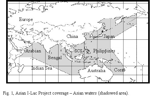
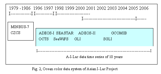
2.2 TIME SERIES AND IMAGES COVERAGE
The Asian I-Lac project
focuses on the Asian waters (Fig. 1, shadowed area). The area
includes northwestern Pacific Ocean and a part of northeast Indian
Ocean. This area is related to about 30 countries, representing
about 60% of the world population. The Asian I-Lac project is
planned to process ocean color data, including ADEOS-I OCTS,
SeaWiFS, |
|
|
|
|
|
ADEOS-II
GLI, GCOM1B GLI and the other ocean color sensors to establish a
continuous time series (10 years from 1996 to 2006) of ocean color
data with high-resolution (1 km) for Asian waters (Fig. 2).
For a better analysis of
OCTS images availability, we split the whole Asian waters into 10
super-regions (Fig 1). These are Arabian Sea, Bay of Bengal,
Indian Ocean, South China Sea (SCS), Philippines Sea, Bohai, Japan
waters, Australia waters, Coral Sea and European waters. European
waters include the Red Sea, Mediterranean Sea, Black Sea, and
Caspian Sea. We then categorized each scene according to its
quality into one of five groups designated A (for the best
quality) to E (for the worst quality). Factors that were taken
into account for this quality judgment included the presence of
clouds.
ḂḂ |
|
3.Results and Discussion
3.1 HIGH SPATIAL RESOLUTION IMAGES AND
ALGORITHM TESTING
OCTS data with 700 m spatial
resolution has been acquired for the global oceans because of the
large capacity of ADEOS-1 data recorder. Now we have a total of
18548 scenes of OCTS data received from ADEOS-1. There are about
350 to 400 scenes in each month on the Asian waters. |
|
|
|
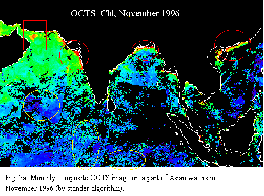
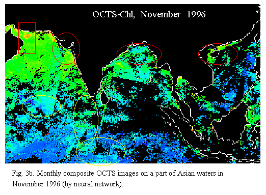
The Asian
I-Lac images cover the whole Asian waters. Fig. 3a is an example
of composite image of OCTS-derived chlorophyll-a (by standard
algorithm) in November 1996. The coastal lines are shown in white
color and clouds are in black color. This image illustrates the
distribution |
|
|
|
patterns of
chlorophyll concentrations on that part of the Asian waters with
good coverage. Chlorophyll concentrations were high in the north
coastal area of the South China Sea, north coastal areas of the
Bay of Bengal, and on the whole northern Arabian Sea, particularly
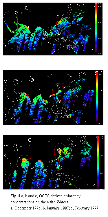
on the mouth of the Gulf of Oman (red circle in Fig. 4a).
Composite cloud-free images are useful for
algorithm testing and application researches. We have able to
build image browsing systems and data selecting systems for this
purpose. By using Asian I-Lac data processing system, we select
cloud free scenes to make composite images for testing of the
present algorithms and developing case-2 water algorithm. Fig 3a
shows chlorophyll-a retried by standard algorithm, and Fig 3b
displays retrieval chlorophyll-a by neural network. The coastal
lines are shown in white color and clouds in black color.
Differences can be noted between those two images by different
algorithm. Chl-a values were high in the coastal area in Fig 3a
(red circles), but they do not appear on Fig. 3b. Chl-a values in
some of open seawaters are higher on Fig. 3b (yellow circles) than
on Fig. 3a. Those results show that neural network may reduce
sensitivity to noise. Asian I-Lac data system can provide ocean
color scientists with capability of testing or developing their
algorithm. It can also provide comparison study among retrieval
concentrations of chlorophyll-a, suspended matter and yellow
substance from the normalized water leaving radiance (nLw) (Tang
and Kawamura, 2000).
top |
3.2
CHLOROPHYLL DISTRIBUTION ON THE ASIAN WATERS
Distribution patterns of chlorophyll (by
standard algorithm) on the Asian waters during December1996 to
March 1997 are shown in Fig. 3a and Fig. 4. The coastal lines are
shown in white color and clouds in black color. |
|
In November 1996 (Fig. 3a), chlorophyll concentrations were high
on the coastal areas, |
|
and
in the northern of Arabian Sea. A patch of intensive high
chlorophyll concentrations appeared on the Gulf of Oman.
In December 1996 (Fig. 4a, composed by 26 scenes), high
chlorophyll concentrations appeared in the Yellow Sea (red
circle) and northern of Arabian Sea, but that patch of
high chlorophyll concentrations previously observed on the
Gulf of Oman had disappeared. Fig. 5b (composed by 47
scenes) shows high chlorophyll value along the coastal
area of China (red circle) in January 1997. Chlorophyll
distribution pattern in the Bohai and the Arabian Sea in
February 1997 are shown in Fig. 4c (composed by 34
scenes). The chlorophyll concentrations were also high in
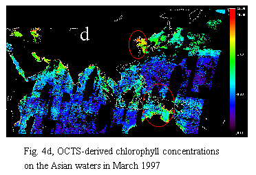
the northern of Arabian Sea (red circle). Fig. 4d
(composed by 52 scenes) is a monthly composite image of
March in 1997. High chlorophyll concentrations can be
identified in the Bohai Sea and the coastal area of
Australia (red circle).
Chlorophyll
concentration, an index of phytoplankton biomass, is the
single most important property of the marine ecosystem (MẀṗller-Karger
et al., 1989; Sarupria, and Bhargava, 1998).
Field data showed that in the northern Arabian Sea, most
of the primary production occurred below the surface
during the SW monsoon from June to September, and during
the NE monsoon from October to January the average of the
primary production is higher than during the premonsoon
from February to May (Qasim, 1982; Sarupria and Bhargava,
1998).By examining annual composite CZCS images, Tang et
al. (1998) reported on the yearly and geographic
variations of pigmentconcentrations
on the continental shelf of China.Pigment concentrations were
high (> 2.0 mg m-3) over the inner shelf along China
and in the Yellow Sea and decreased seawards and southeastwards
(offshore) with a minimum value (<0.5 mg/m-3) in the
Philippines Sea.OCTS-derived chlorophyll-a concentrations are
comparable withCZCS measurements, and Asian |
|
|
|
I-Lac images provide
more information for the whole Asian waters area with a better
spatial resolution.
top |
|
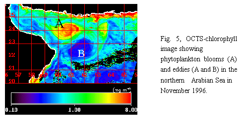
3.3 PHYTOPLANKTON BLOOMS ON THE
NORTHERN ARABIAN SEA
When processing OCTS
images for the Asian waters, we noticed intensive phytoplankton
blooms with high chlorophyll values (>8mg m-3) in
the northern Arabian Sea (small red box in Fig 3a,b; Fig. 6) in
November 1996. The blooms had a round shape of 100 km in diameter
in the |
|
|
Gulf
of Oman (60.5 oE, 24. oN) (A in Fig.5). The
bloom appeared as an anticyclone eddy feature and was accompanied
by another cyclone eddy feature of lower chlorophyll values (B in
Fig.5) in the southwest (61.5 oE, 22.5 oN).
With high spatial resolution, Fig. 5 also shows some other eddy
features on that area.
The northern Arabian Sea is a semi-enclosed
sea. Despite the observations made during the international Indian
Expedition (IIOE), lager regions of the northern Arabian Sea,
including the Persian Gulf and the Gulf of Oman, have remained
unknown or poorly know (Qasim, 1982; Shetye et al., 1994).
Satellite ocean-color for chlorophyll concentrations is a new
approach for understanding of the marine biology, such as
phytoplankton blooms, and oceanic physical processes, such as
eddies. Satellite ocean colour data have been used in studies of
pigment concentration, phytoplankton blooms, and harmful algal
blooms (HAB) in the Chinese coastal oceans (Tang et al., 1998,
1999). By analysis of CZCS ocean colour images, Tang et al. (1999)
reported big phytoplankton blooms southwest of the Luzon Strait in
the South China Sea. The phytoplankton bloom was related to the
upwelling in winter season. For this observation of big
phytoplankton blooms with eddies on the Gulf of Oman, more
investigations are ongoing.
|
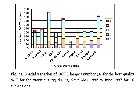
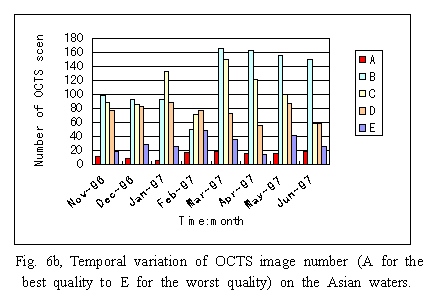
3.4 AVAILABILITY OF
OCTS IMAGES
OCTS image coverage and data
quality were analyzed for the period of November 1996 to June
1997. Each scene was categorized according to its quality into one
of five groups designated A (for the best quality) to E (for the
worst quality). Spatial variation of OCTS images availability for
10 sub-areas is shown in Fig. 6a, and temporal (monthly) variation
of OCTS availability of OCTS scenes is shown in Fig. 6b. The
availability of OCTS images varied from area to area (Fig. 6a),
and also varied from month to month (Fig. 6b). There are more
images |
|
|
|
of A-level
(best quality, more than 95 % coverage) in the Arabian Sea and Bay
of Bengal, than in the Philippines Sea; there are also more images
of E-level (0-25% coverage) in the Australia waters and
Philippines waters than in the Arabian Sea. The availability of
OCTS images is good for the Arabian Sea and the Bay of Bengal,
particularly in November and December 1996, while the image
quality for Australia waters is not as good as that of Indian
Ocean. Good OCTS images can be seen on the Japanese waters in
April 1997. The total number of images for each month increased
from November 1996 to March 1997 and then decreased lightly, the
percentage of god mage (A and B level) increased from March 1997
on (Fig. 6b).
It shall be mentioned that the number of OCTS
scenes is also related to the size of area when we analyzed the
spatial variation of OCTS scenes number. The number of scenes is
small on the Bohai Sea. One of the reasons is that the Bohai Sea
area is relatively small compared with other sub-regions. The good
image coverage on the Northern Arabian Sea may be attributed to NE
monsoon in winter season. More analysis is ongoing. |
|
|
4.Summary
The Asian I-lac Project
is generating a long-term time series of the ocean color images
with high spatial resolution on the Asian waters. The data system
provides ocean color scientists with capability of testing or
developing their algorithm, and transferring images for their
research. The OCTS-derived chlorophyll concentrations varied from
time to time on the Asian waters. In the winter season,
chlorophyll concentrations were high on the north of Arabian Sea,
and along the coasts of China and Australia. Intensive
phytoplankton blooms and eddies were observed in the Gulf of Oman
in the north of Arabian Sea. OCTS image coverage is good for the
northern Arabian Sea during the winter season. The reprocessed
Asian I-Lac OCTS images demonstrate the potential of the
wide-ranging ocean color data with 700 m spatial resolution in
research in marine biology, environment, and development of ocean
color algorithms.
top |
|
ACKNOWLEDGEMENTS
Asian
I-Lac Project is supported by the National Space Development
Agency of Japan (NASDA). We appreciate all Asian I-Lac team
members for working on Asian I-lac Project. We acknowledge Mr.
Wataru Takahashi from JAPAN NUS CO., LTD., and Mr. Akihiko Tanaka
from Tokai University for their assistance in computer program. We
specially appreciate Dr. Alain Pittet from NestlẀḊ Research
Center, Lausanne, Switzerland, for his assistance in technical
writing.
|
|
REFERENCES
GEOHAB, (1998).
ḂḞGlobal Ecology and Oceanography of Harmful Algal Blooms.Ḃḟ
Joint SCOR-ICO Workshop, Havreholm, Denmark. pp. 30 ẀC 32.
Kawamura H. and
the OCTS Team, (1998). ḂḞOCTS mission overview.Ḃḟ Journal of
Oceanography. Vol. 54, pp. 383-399.
Kawamura H.,
(2000). ḂḞStrategic plan of the Asian I-Lac projectḂḟ. Center
for Atmospheric and Oceanic Study, Tohoku University. pp.30. (In
Japanese)
MẀṗller-Karger,
F.E., McClain, C.R., Fisher, T.R., Esaias, W.E., Varela, R.,
(1989). ḂḞPigment distribution in the Caribbean Sea:
Observations from space.Ḃḟ Progress in Oceanography, Vol. 23,
pp. 23-64.
Qasim S.Z,
(1982). ḂḞOceanography of the northern Arabian Sea.Ḃḟ Deep-Sea
Research, Vol. 29 (9), pp. 1041-1068.
Sarupria J.S and
R.M.S. Bhargava, (1998). ḂḞSeasonal distribution of
chlorophyll-a in the exclusive economic zone (EEZ) of
India.ḂḟIndian journal of Marine Sciences. Vol.27, pp:292-297.
Shetye S.R,
A.D.Gouveia, and S.S.C. Shenoi, (1994). ḂḞCirculation and water
masses of the Arabian Sea.Ḃḟ In Lal D Edited: Biogeochemistry
of the Arabian Sea. Indian Academy of Sciences.
Bangalore.pp9-25.
Tang D. L., I-H.
Ni, F. E. MẀṗller-Karger & Z. J. Liu, (1998). ḂḞAnalysis of
annual and spatial patterns of CZCS-derived pigment
concentrations on the continental shelf of China.Ḃḟ Continental
Shelf Research. Vol. 18 (1998), pp. 1493-1515.
Tang D. L., I-H.
Ni, D. R. Kester and F. E. MẀṗller-Karger, (1999). ḂḞRemote
sensing observation of winter phytoplankton blooms southwest of
the Luzon Strait in the South China SeaḂḟ. Marine Ecology
Progress Series. Vol. 191, pp: 43-51.
Tang D. L., D.
R. Kester, I-H. Ni and Y.Z. Qi, (2000). ḂḞA study of harmful
algal blooms in Hong Kong in winter 1998Ḃḟ. 31st Annual
Symposium of the Estuarine and Coastal Sciences Association.
Bilbao, Spain. July. 2000. pp.132.
Tang D.L., and
H. Kawamura, (2000). ḂḞAsian I-Lac Project ẀC Ocean color
images of long term time series and high spatial resolution for
the Asian watersḂḟ. The 11th JSPS Joint Seminar on
Marine Science. Tokyo, Japan.
Yoder, J.A.,
McClain, C.R., Feldman, G.F. and Esaias, W.E., (1993). ḂḞAnnual
cycles of phytoplankton chlorophyll concentrations in the global
ocean: a satellite viewḂḟ. Global Biogeochemistry Cycles 7, pp.
181-193.
|
|
 home
top home
top |
|
|
|
|